The Southampton Center Historic District and The Lockville Historic District
A historic district is a group of buildings, properties or sites that have been designated by one of several entities on different levels as historically or architecturally significant. Districts can greatly vary in size: some have hundreds of structures, while others have just a few. The National Register of Historic Places is the official list of the American Cultural resources worthy of preservation. Listing in the National Register recognizes that the area or building is important to the history of the community, state, or nation; allows owners of income-producting properties to qualify for federal tax incentives for rehabilitation, and provides limited protection against federal/state projects.
Southampton has two National Register Historic Districts – The Southampton Center Historic District and The Lockville Historic District. The Southampton Center District… was designated in 1991 and incorporates portions of High Street, College Highway, and East Street. The town center developed around the meeting house, and has traditionally been the focus of prime residential and civic development.
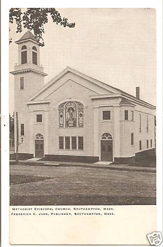
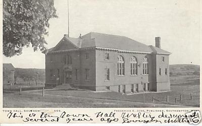
The area includes the Congregational and former Methodist churches (demolished in 1997), the Fire Station (originally the Distric #1 Schoolhouse), the former Town Hall, the former Town Library, and several buildings that functioned as general stores. East Street is lined with attractive 18th and 19th centure village residences, including the Woodbridge House and the Swift House. Along College Highway are several old farmhouses and a sprinkling of Colonial Revival and Craftsman styles. High Street also contains a number of 18th century and 19th century residences. The rise in elevation away from the Town Center makes the village a geographical as well as cultural focus.
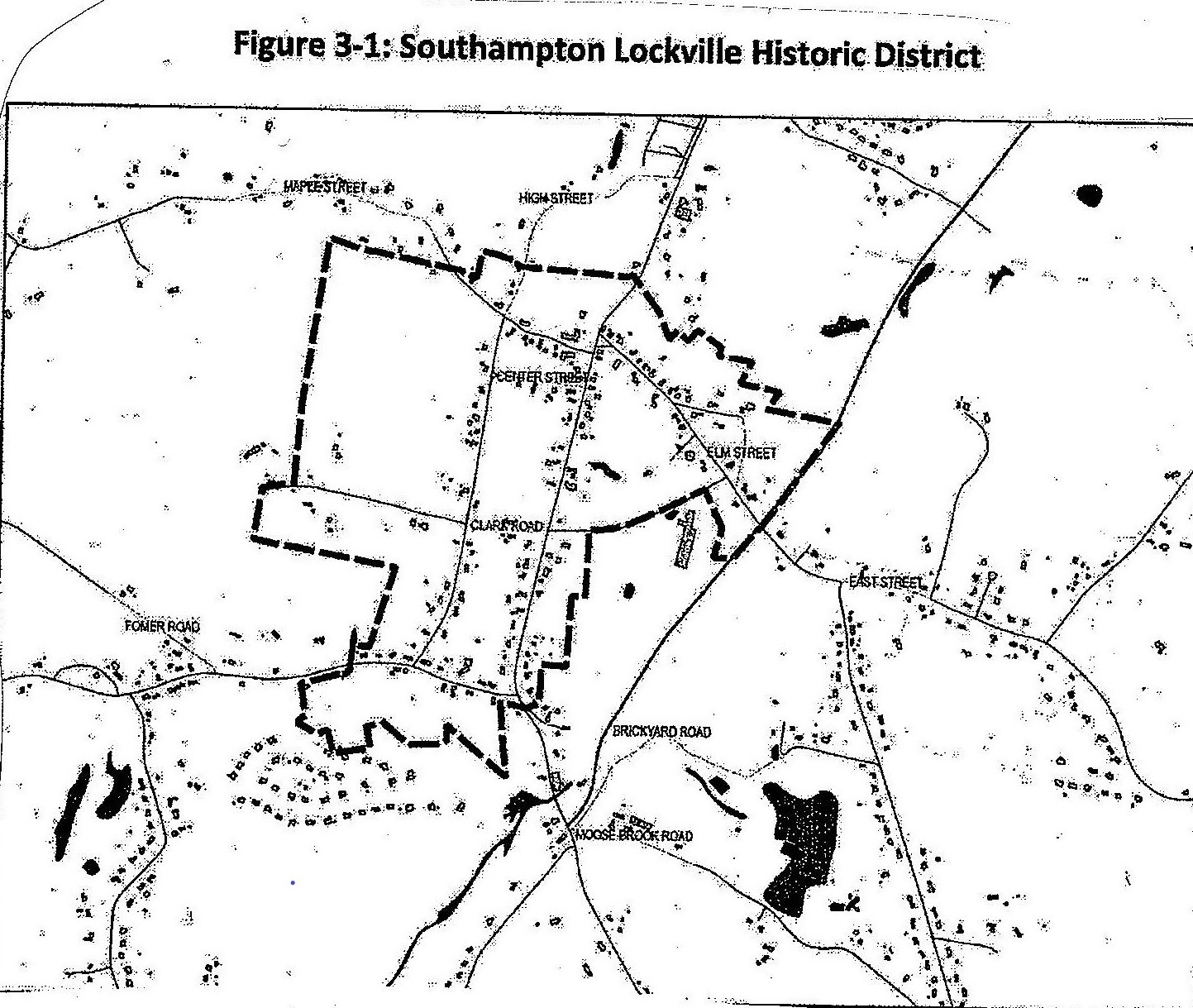
Designated in 2001, the 240-acre Lockville Historic District is significant as a largely untouched industrial area which supported a sawmill, a gristmill, a tannery, a cider mill, a shingle mill, a whip shop, and a piano leg factory approximately a mile south of the town center along the Manhan River. The development of the area was spurred by the establishment of the New Haven-Northampton Canal, which operated from 1835-1847. The construction of three canal locks, a canal warehouse, and a hotel for canal travelers along the New Haven and Northampton Canal system contributed to the area being named “Lockville”.
The dictrict has 11 contributing buildings, four structures, and two sites. The principal buildings include the Icabod Strong House (1768), the Phineas Strong House (1833), the Lockville Hotel (1828), the Canal Storehouse (1832), the Lyman Mill (1854) and the Lyman Sheet Metal Company complex. The principal structures include the canal lock remnant (1835) and the mill dam which impounds Lyman Pond itself.
The Russellville area is listed on the Massachusetts State Inventory of Historical Places. Russellville developed as a small milling and manufacturing center in the eary 19th century. While most of the mills are gone, the surviving residences suggest the prosperity of the area in its prime. The Russellville area was settled about 1800 and by 1836 had develped enough to warrant establishment of a district school. The Manhan River supplied power to several small mills, including a grist mill, shingle mill, sawmill and a clover seed mill. A cider mill and several clothier mills were also in operation, supported by a blacksmith shop and a cooper. By 1865, most of the Russellville mills had been abandoned or closed down.
One of the earliest areas of Southampton to be settled, West Part is situated along the southwest branch of the Manhan River in the northwest corner [of] town. Elias Lyman and Samuel Burt built the first two homesteads there in the mid 1730s, and over the next 150 years, forty more were established. Several saw and grain mills utilized the river for power. West Part was a lively and productive section of town with its own schoolhouse and cemetery until the 1890s, at which time the city of Holyoke petitioned the General Court in Boston to request this area of land for [the] purpose of building a reservoir. Granted in 1894, Holyoke began to purchase and clear the land and remove the homesteads. The dam for the White Reservoir was completed near the Westhampton town line in 1912, and the reservoir was filled. In the 1950s, Holyoke purchased additional Southampton land and built the Tighe Carmody Reservoir. When this reseroir was complete, the White was drained, and after an unsuccessful leak repair, abandoned. At present, the city of Holyoke owns approcimately 2, 600 acres of land in the West Part section of town, which is inaccessible to the public. Of the original settlement, only the cemetery and the nearby Dady House remain.
Currently, there are no individual buildings outside the designated National Historic Districts in Southampton listed on the National or State Register, or within a Local District. All of the buildings over 100 years old are listed on the Massachusetts State Inventory of Historic Places. Listing on the state inventory helps communities keep an active list of historic buildings, areas, objects, and structures in the community, and can assist when working for designation status on the National or State Register of Historic Places. The town’s Historical Commission has been diligent about keeping this inventory up to date, and all houses that are over 100 years old in town are included on the state inventory…
According to the Massachusetts Historical Commission (MHC) 1982 Reconnaissance Survey Town Report for Southampton, there are a number of building of historical significance from the Colonial, Federal, and Early and Late Industrial period that still survive in the community. The historically significant buildings are all listed on the state historical inventory.
The earlierst surviving houses date to the 1730s and 1740s. These include the Eleazar Hannum House (c.1743), the Ebenezer Kingsley House (c.1730), the Elisha Pomery cottage (c.1743) and the Jonathan Judd House (c1743). The Hannum and Kingsley Houses are significant due to the architectural integrity. In general, the town’s Colonial houses are scattered throughout town rather than clustered in the town center. Examples were observed by MHC on Crooked Ledge and Gunn Roads, East Street and College Highway (Route 10).
At least a dozen Federal houses and cottages are known to survive in Southampton. Most homes of this style were built before 1810, with a number of houses built in the 1790s. The two most outstanding resources remaining from this period are the 1793 Doctor Sylvester Woodbridge House, known as Woodbridge Hall, and the 1788 Second Meeting House (Congregational Church).
A number of houses and cottages were built in Southampton during the Early Industrial Period, most likely in the 1850s and ’60s. Clusters of period houses were observed by MHC at Southampton Center, on High Street and on Route 10, and at Russellville. Individual houses of the period were noted in scattered locations on Middle and Gunn Roads, Maple and East Streets and Pomeroy Meadow Road. Several institutional buildings were also built during this time, such a Methodist Church (1844), District School #1 (1863 )and District School #2 (1845). The 1863 school has functioned as a fire station since the 1940s. Originally, the District #2 schoolhouse was located at the corner of Pomeroy Meadow Road and Glendale Road. The Historical Commission moved it to Conant Park in 1975 and restored the wooden structure. This structure has historical value and is open to the public on the Fourth of July, Celebrate Soouthampton (formerly known as Old Home Day) and Sunday afternoons during the summer months.
Perhaps as many as two dozen houses and cottages were bult in the town in the Late Industrial period. Most are located at or near the town center, with examples noted on Route 10, East Street, High Street and Fomer Road.
Source: Southampton Master Plan June, 2013
Return to the Edwards Public Library website.