A Short History of Southampton*
Introduction
The Town of Southampton is a 28.96 square mile community located in Hampshire County on the western uplands of the Connecticut River Valley in Western Massachusetts. The town straddles two of the state’s major water sheds, those of the Connecticut and the Westifle Rivers. The topography rises from the east to the west, and the Pomeroy and Little Mountains are visible landmarks from distant neighboring towns.
Traditionally a farming community, Southampton is a rural residential community that serves as a gateway to the countryside. The town is ordered by expanding urban centers (Westfield, Holyoke and Easthampton) along the valley side predominately to the weast and south, and by sparsely populated highland villages (Montgomery amnd Westhampton) to the north and west.
Chronology (10,000 B.C.-1620)
Native people inhabited, traversed and hunted this region of 10,000 years. This history exists in oral traditions and archaeological evidence. Research reveals that the Native Americans greatly affected the landscape. Largely agricultural people who grew corn, beans and squash as staple food, Native people managed the woodlands and wildlife populations by setting fire to the forests. Seasonally migratory, communities moved from inland areas in the summer to coastal regions during the winter. Communities settled along ribvers, where flat fertile fields were cleared for agriculture. The Connecticut River, the longest river in New England, was and important transportation route. Along the river, deep alluvial soils offered excellent conditions for farming. Tributaries, such as the Manhan River, provided access to inland regions and abundant game. These people lived in relationship to the land far differently than European settlers.
In the 1630’s, Proprietors of the Massachusetts Bay Colony purchased uninhabited land from the Nonotuck Indians and settled Northampton. Caleb Pomeroy, one of the town’s original settles, petitioned the General Court of Massachusetts to gran him land in 1680.
First settled by colonists in the 1680s, these entrepreneurs parnered with the local Native Americans and established a lucrative fur trade.
In 1730, Southampton was established as a precinct, and thirty families drew land grants. In return, there were required to build at least a one-room house withon two year, and improve a certain number of acres. Improvements generally mean clearing, cultivation and enclosing land.
The nearest church was eight mile away in Northampton. In 1743, Jonathan Judd preached in the town and continued to do so for sixty years. The church ws reinforced as a fortress against Native American raids. This frontier settlement was the farthest northwest, with no other between it and Canada.
By 1753, most of the Native American raids had subsided and setllement increased. At tis time, Southampton was incorporated as a district with hearly all town privileges. At this same time a schoolmaster, Silas sheldon, was hired. Later he gave the town a considerable gift of $2,500 for the establishment of Sheldon Academy. In 1773, Southampton had it first town meeting at which the official name, “Southampton”, was adopted.
Chronology (1775-1830)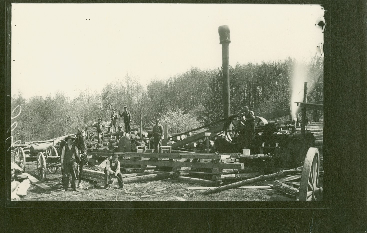
The town’s industries consited of lumbering and forest clearing and there were many sawmills within the town. In addition to sawmills, Southampton also had a charcoal plant, bark mill, match mill, turning mills for axe helves and piano legs, a chair factory, and two shingle mills. The town also had a large tannery, gristmills, whip factories, a woolen mill, clothier works, and a thriving network of rum and brandy distilleries.
As forest cleared, more rich agricultural lands were uncovered, leading to large acreage of farming. Two of the more recent and publicized enterprises were the lead mines, which had their heyday in 1770, and the Northampton-New Haven Canal which passed through the town and was in operation for thirteen years.
Southampton Lead Mines
Along the northen end of Lead Mine Road, in the general vicinity where the boundaries of Easthampton, Westhampton, and Southampton meet, lead mines once operated.
Robert Lyman, a hunter, discovered the mines in 1679 when all the land belonged to Northampton. Boston interests and capital spurred lead mine development after Northampton granted 100 acres to be worked. However, capital waned and product was slight, and the mine was abandoned.
In 1764, nearly seventy years later, New York interest re-opened the mines. The working crew included Ethan Allen of Revolutionary War fame. The richest veins of lead were found in the Southampton section. A stamping mill with six hammers and a smelting furnace were erected. Operations reached their height in 1770. The Revolution, however, forced abandonment of the mine.
Again Boston interest re-opened the mine in 1807. This time the mine was open for about thirteen years. Shafts ran as long as 726′ laterally and as deep as 110′.
Sporadic interest from New York once again re-opned the mine in 1851. In 1863, 150 men, two powerful steam engine, and efficient stone crusing machines were located at the mines, and machinist and blacksmith shops were erected. The final abandonment of the mines occured in 1865.
Chronology (1830-1870)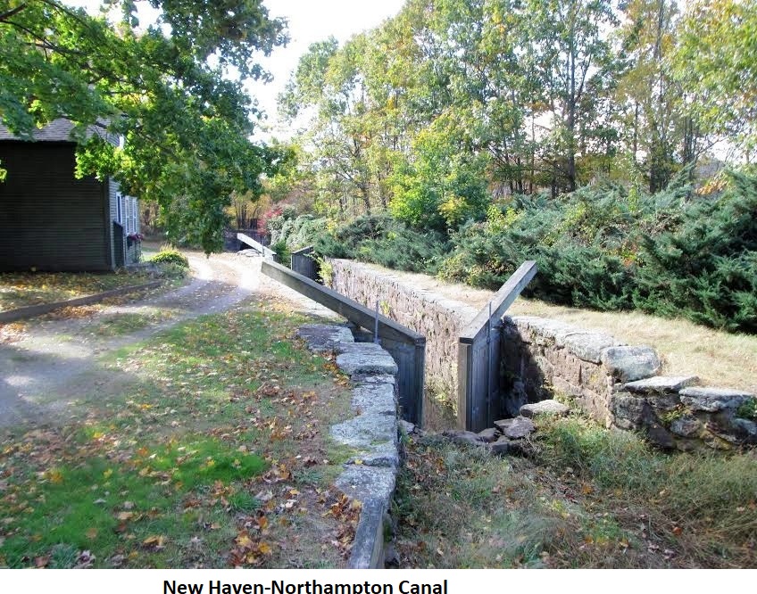
In the early 1800s, heavy freight was transported by water carriers. Freight was transported up from Connecticut by means of slow flat boats which were pulled along the Connecticut River. Spring water rises made this mode extremely difficult and slow. Speculation ran high with plans drawn to continue the canal to the Vermont-Canada line where the Canadians would join it with the St. Lawrence River. By 1822, plans for canal construction from New Haven to Northampton materialized, incluiding contruction plans through seventeen towns, including Southampton. Excavation was begun by two companies, one in Connecticut and one in Massachusetts.
New Haven-Northampton Canal (1835-1847)
The official opening of the canal was on July 29, 1835. The canal had two summits. The first was at the Massachusetts-Connecticut line, 20′ above sea level. The other, after the canal dropped to 98′ in Westfield, was at Timber Swamp, just a mile south of the southampton line, 231′ above sea level. A feeder canal from the Farmington River supplied the Connecticut section with water, while the Congamond Lake supported the Massachusetts section A feeder canal from Salmon Falls (now Woronoco) pro9vided water at Timber Swamp.
The canal specification: 24′ wide at the bottom; 34′ wide at the surface; water depth 4′; horse tow paths 10′ wide, 2-5′ above the water level. The boats were 75′ long, 11′ wide and 7′ high. Pleasure boats carried from 150 to 200 people. The passenger fare from Northampton to New Haven was $3.75, including meals, and the time through was approximately twent six hours.
There were thrirty-two locks in Massachusetts and twenty-eight in Connecticut. The locks were 80′ lon, 14′ wide. The Southampton asection had 6 locks: one near Route 10 to the south with a 10′ elevation change; a 60′ aqueduct near Lyman’s Tin Shop bridged the Manhan River, followed immediately by three more 10’locks, and two additional locks. The next lock system lowered the canal into Easthampton at the town line at the North Branch of the Manhan River, where five locks lowered the canal 36′.
The construction cost was over one million dollars for the eighty-mile canal (approximately $13,000/mile). Unfortunately, the canal never realized its potential. The railroad is attributed to the final downfall; however, structural problems had greatly hindered its success, including bank slumpage and leaks due to muskrats, floods, poor soils, droughts, decaying of wooden locks, and very leaky aqueducts promoted by decay.
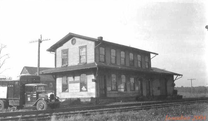
In 1847, the New Haven and Northampton Canal Company declaired bankruptcy and canal ceased operation. By 1855, the right-of-way had been purchased and the “Canal Railroad” had been completed. In Southampton, the railroad lines were constructed in the canal bed from East Street to the Westfield Line.
Chronology (1870-1945)
Robert Lymnan discovered lead in the north part of town in 1678 and lead mines operated in this area until 1868. The lead mines were never profitable, but they continued as a speculative business venture for quite some time. Over the centuries, mineral resources permitted several other mines, quarries, and brickyards to operate in town.
Numerous springs on Little Mountain provided water for the village center. As early as the 1820’s, wooden pipes carried water from the mountain springs to village homes. A group of local businessmen established the Southampton Aqueduct Company, the Town’s first private water company, in 1865. The company reorganized and became the Mountain Spring Water Company and later the Mountain Spring Water Works, which provided the town center residents with water until 1931, when the town bought out the troubled company
During the mid-to-late 19th century, mill industries began to spring up throughout Massachusetts. Southampton, however, was not inclined to support these businesses and the attendant influx of immigrant workers. Many of the businesses began in neighboring Easthampton. Effectively, this helped to preserve Southampton’s rural tradition, and agriculture remained its primary economic base until the end of World War II.
Chronology (1945 to present)
In 1977, Southampton initiated town planning. The town wa a leader in conservation planning and preservation, and the Commonwealth of Massachusetts acknowledged Hazel Young, Conservation Commissioner, for her efforts in preservation and conservation.
Southampton the Community Preservation Act in 2001 and its local committee began work in early 2002. Funds are used for planning activities in the four areas o9f open space, recreational land, historic resources and community housing.
Southampton’s Conservation Commission has worked to restore 550 acres of conservation properties under their stewardship. In the summer of 2009, the Town of Southampton purchased a Conservation Restriction on a 200 acre parcel call the Wolf Hill Sanctuary.
Today, Southampto is a community of commuters and a few farmers. Despite the loss of farms, residents perceive Southampton as a rural community with a small town character. Currently, it is not agriculture but services, trade, mining and construction that comprise the bulk of its economic base. Residents place a high value on the remaining farmland and open space and continue to work to preserve and protext these prized resources.
Southampton’s positive attributes of high quality of life and close proximity to urban areas make it a desireable place to live. These characterics also ceate development pressure that are altering Southampton’s rural character. It is one of the Commonwealth’s most rapidly growing towns. Determination of the appropriate jobs/housing balance is expected to guide the community’s future development.
*Author unknown